News
Helicopter Deployed to Rescue Lost Hiker in Stevens Gulch Near Kelso Ridge
What started as a day of hiking ended with spinning rotors and flashing lights. On Sunday afternoon, June 22, a hiker lost in the Stevens Gulch area near Kelso Ridge was safely located after an intense rescue mission involving a helicopter, ground teams, and multiple emergency crews.
It was a textbook collaboration between Alpine Rescue Team and Flight for Life. But it also served as yet another reminder: Colorado’s high country doesn’t care how experienced you are.
Afternoon Hike Turns Into Emergency
The initial 911 call came early Sunday afternoon. A hiker, alone and disoriented, had veered off the main route near Kelso Ridge—a steep and rugged side of the popular Grays and Torreys Peaks area. Cell reception was patchy. GPS location? Vague at best.
Rescuers didn’t waste time.
The Alpine Rescue Team, already familiar with the terrain, mobilized alongside Flight for Life Colorado, Clear Creek Fire Authority, and CDOT units stationed nearby.
Within hours, Stevens Gulch had transformed from a quiet alpine trailhead into a logistical hub for high-altitude rescue coordination.
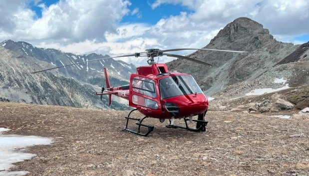
Helicopter Becomes the Lifeline
The terrain made foot access difficult. Loose rock, steep inclines, and lingering snow patches ruled out any fast ascent by ground.
So the team brought in their best eye in the sky.
Flight for Life’s helicopter launched and used a nearby I-70 overpass at mile marker 221 as its landing and staging zone. From there, aerial scans began. Spotters searched every ledge and ravine from the air.
By 2:20 p.m., they’d found the hiker.
He was upright, fatigued, and waving. He hadn’t fallen, but he was visibly cold and dehydrated. Rescuers believe he had been off-route for several hours.
Extraction, Then Evaluation
Rescuers airlifted him out using a long line—essentially a tethered rescue from the helicopter’s belly. The process, though efficient, isn’t as fast as people think. High-altitude flying is tricky, especially near rock walls.
Once on solid ground, the hiker was evaluated on-site. Officials say he showed signs of exposure and fatigue but no serious injuries. Out of caution, he was expected to be taken by ground ambulance to a nearby hospital.
A statement from Clear Creek EMS said: “He was alert and cooperative, and we expect a full recovery. He’s lucky to have called for help when he did.”
Why This Area is a Frequent Trouble Spot
Kelso Ridge isn’t beginner-friendly. It’s a Class 3 scramble with exposure, loose rock, and no room for error.
While the standard route to Grays and Torreys Peaks is well-marked and manageable, Kelso Ridge can lure hikers off-course with deceptive terrain and what appears to be “shortcut” trails.
Some known hazards of the area include:
-
Narrow ledges and unexpected drop-offs
-
Rockfall danger from above
-
Hidden snowfields well into summer
-
Unstable footing due to erosion
Even experienced hikers get surprised.
“It’s beautiful up there, but if you get off-track, you can be in trouble fast,” said one Alpine Rescue volunteer. “People underestimate how thin the margin is between ‘fun hike’ and full-blown rescue.”
Multi-Agency Response Was Key
This wasn’t a one-team show. The full list of responders included:
-
Alpine Rescue Team
-
Flight for Life Colorado
-
Clear Creek Fire Authority
-
Clear Creek EMS
-
Colorado Department of Transportation (CDOT)
CDOT helped with traffic control on I-70 as the overpass became a staging site. Fire crews remained on standby in case of secondary incidents.
Rescuers praised the coordination between agencies. With summer traffic on I-70 and weekend hikers crowding the region, every minute counted.
“It worked because everyone moved like clockwork,” one EMS official said. “From air to ground, every team showed up prepared.”
No Blame, Just Lessons
Officials are not releasing the hiker’s name. They’ve also emphasized that he didn’t make any obviously reckless decisions.
“He wasn’t doing anything crazy,” said one SAR crew leader. “He just took a wrong turn and didn’t realize how far off he was. It happens. We just want folks to learn from it.”
A few things they encourage all hikers to remember:
-
Always carry a topographic map—even if you have a phone
-
Let someone know your route and timeline
-
Pack for sudden weather changes—light rain becomes dangerous fast
-
If you’re unsure, turn back
And most critically, don’t wait too long to call for help.
This hiker called early, and that may have saved his life.

Warhammer Horus Heresy Super-Heavy Tanks Share a Plastic Chassis

Best Prime Day 2026 Desktop PC Deals, From $524 to $3,299

iOS 27 Wallet Adds 7 New Features, From Bill Splitting to Custom Passes

Colombia Edge DR Congo as Muñoz Books World Cup Knockout Place

Warriors Take Yaxel Lendeborg, the Oldest Pick in the 2026 NBA Draft

Sega’s $49.99 Sonic Classic and Modern Bundles Hit Switch in October

Microsoft Adds 8GB Surface Pro and Laptop at $849 and $949

Star Wars: Galactic Racer Is a Roguelite Racer With a Podracing Skin

Douze Dixièmes Closes Five Months After MIO: Memories in Orbit

Google TV Streamer Update Quietly Introduces Home Speaker Pairing

Pulisic Ends Drought but US Defending Clouds 3-2 Senegal Win

French Open Line Call Furor Overshadows Fonseca Upset of Ruud

Stuntman Hollywood Revives the PS5 Stunt Racer After 19 Years

Tomb Raider: Legacy of Atlantis Gets February 2027 Release

Ace Combat 8: Wings of Theve Lands October 2 With a Big Online Bet

Chronic Kidney Disease Now Strikes 788 Million Worldwide

Little Nightmares 2 Reaches Switch 2 With No Free Upgrade Path

007 First Light’s $202 Million Bet: Denmark’s Priciest Game Ever

Destiny 2’s Final Update Pulls Its Biggest Crowd in Two Years

God of War Laufey Brings Back the Jump Button After 13 Years
-

 TECHNOLOGY3 years ago
How to Adjust a Bulova Watch Band – An Easy Guide
-

 News3 years ago
Fred Pentland: Athletic Bilbao’s English mentor who changed the essence of Spanish football
-

 FINANCE3 years ago
Tax Planning for Every Season: Guide to Maximizing Your Tax Benefits
-

 Education3 years ago
African Ministers New Education Plan
-

 BUSINESS3 years ago
What is Entrepreneurial Operating System? A Comprehensive Guide to EOS
-

 Education3 years ago
Innovate Your Learning Journey with Technology and Enhance Education
-

 News3 years ago
Russians formally out of World Athletics Championships
-

 BUSINESS3 years ago
Top 9 Most Expensive American Cities to Rent an Apartment