The Atlantic has tiptoed into hurricane season with a whisper, but experts warn that silence can be deceiving — and the coming months could churn out a different story.
A Slow Start, But Three Names Already
June 1 marked the official beginning of hurricane season, and as we roll into July, we’ve already ticked through three names: Andrea, Barry, and Chantal.
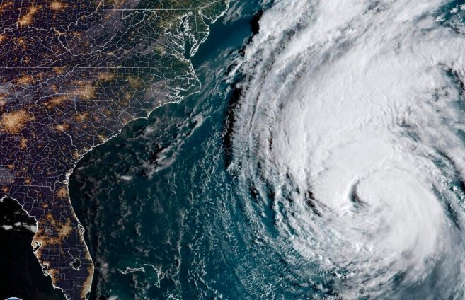
One line here: Chantal is now swirling off the Carolinas, tossing up dangerous rip currents and enough rainfall to soak beach towels and tempers alike.
So far, none of these storms have escalated into monsters. But history shows early quiet doesn’t mean much — in fact, some of the worst Atlantic hurricanes have formed late in the season when ocean temperatures really get cooking.
The Experts Weigh In: Numbers Point To An Active Season
So what does the crystal ball say?
The National Oceanic and Atmospheric Administration (NOAA) predicts the Atlantic will see between:
-
13 to 19 named storms,
-
6 to 10 hurricanes,
-
and 3 to 5 major hurricanes this season.
Colorado State University (CSU), another trusted forecaster, expects about 17 named storms, 9 hurricanes, and 4 major hurricanes. That lines up pretty well with NOAA’s range — a solid clue that we’re looking at near- to above-normal activity.
How Does This Stack Up To Average?
On average, the Atlantic kicks out 14 named storms, 7 hurricanes, and 3 major hurricanes per season.
So if NOAA and CSU are right, 2025 could be busier than your typical hurricane stretch.
One short line here: It wouldn’t be the first time the tropics surprise us.
Lessons From 2024’s Busy Season
Last year, we ended up with 18 named storms, 11 hurricanes, and 5 major hurricanes — a notch higher than the average. 2024 even served up two Category 5 hurricanes, which hasn’t happened in the Atlantic since 2019.
Meteorologists say those Cat 5 storms were fueled by record-warm sea surface temperatures. It’s the same warning flag this year, with Atlantic waters already running a few degrees hotter than normal. Warm water is hurricane fuel — like tossing gasoline on an already smoldering fire.
Why The Slow Start Doesn’t Mean Much
People often think an early calm means a mild season — but the Atlantic’s track record says otherwise.
One sentence here: September is historically the month when the tropics roar to life.
Some of the worst hurricanes on record, like Katrina (2005) or Irma (2017), didn’t become monsters until mid to late season. It’s all about timing — as the ocean heats up through summer, conditions become more favorable for storms to strengthen fast.
Rip Currents, Rainfall And The Sneaky Dangers Of Weak Storms
Chantal may not have grown into a powerhouse, but it’s still packing a punch for beachgoers. Coastal communities in the Carolinas have issued rip current warnings, and lifeguards are working overtime to keep swimmers safe.
A lifeguard captain in Myrtle Beach said, “We worry when people see a tropical storm and think it’s no big deal. The currents can pull you out before you know it.”
Flash flooding is also a real threat. Chantal is expected to drop a few inches of rain in a short window, turning roads into rivers in low-lying neighborhoods.
Six Months Of Watchful Eyes
The hurricane season officially stretches from June 1 to November 30 — six months of weather models, spaghetti plots, and nail-biting for coastal residents.
Here’s a look at how last season compared:
| Season | Named Storms | Hurricanes | Major Hurricanes |
|---|---|---|---|
| 2024 | 18 | 11 | 5 |
| 10-Year Average | 14 | 7 | 3 |
| 2025 Forecast (NOAA) | 13–19 | 6–10 | 3–5 |
One line here: All it takes is one direct hit to turn an entire season from ordinary to unforgettable — for all the wrong reasons.
Preparing While It’s Calm
Emergency managers say the quiet start is the perfect window to double-check hurricane kits, review evacuation routes, and make sure insurance is up to date.
One Florida homeowner said, “I’d rather waste a weekend getting ready than fight for batteries and bottled water when a Cat 4 is a day away.”
And then there’s the question of flood insurance. A lot of people still assume homeowners insurance covers flooding — it usually doesn’t. After hurricanes, that misunderstanding leaves families in a world of financial hurt.
Climate Patterns Add Another Wild Card
Meteorologists are also watching the shifting El Niño and La Niña patterns, which can strengthen or suppress hurricane activity.
One forecaster from CSU explained, “A fading El Niño could open the door for more storms in the Atlantic. Less wind shear means storms have a better shot at organizing and intensifying.”
Eyes On The Horizon
With Andrea, Barry, and Chantal already named, the season is technically ahead of pace. If the forecasts hold true, we could see names like Don, Emily, and Franklin spin up before long.
One short line here: Residents from the Gulf Coast to New England know the drill — watch, wait, and hope the big one never comes.