News
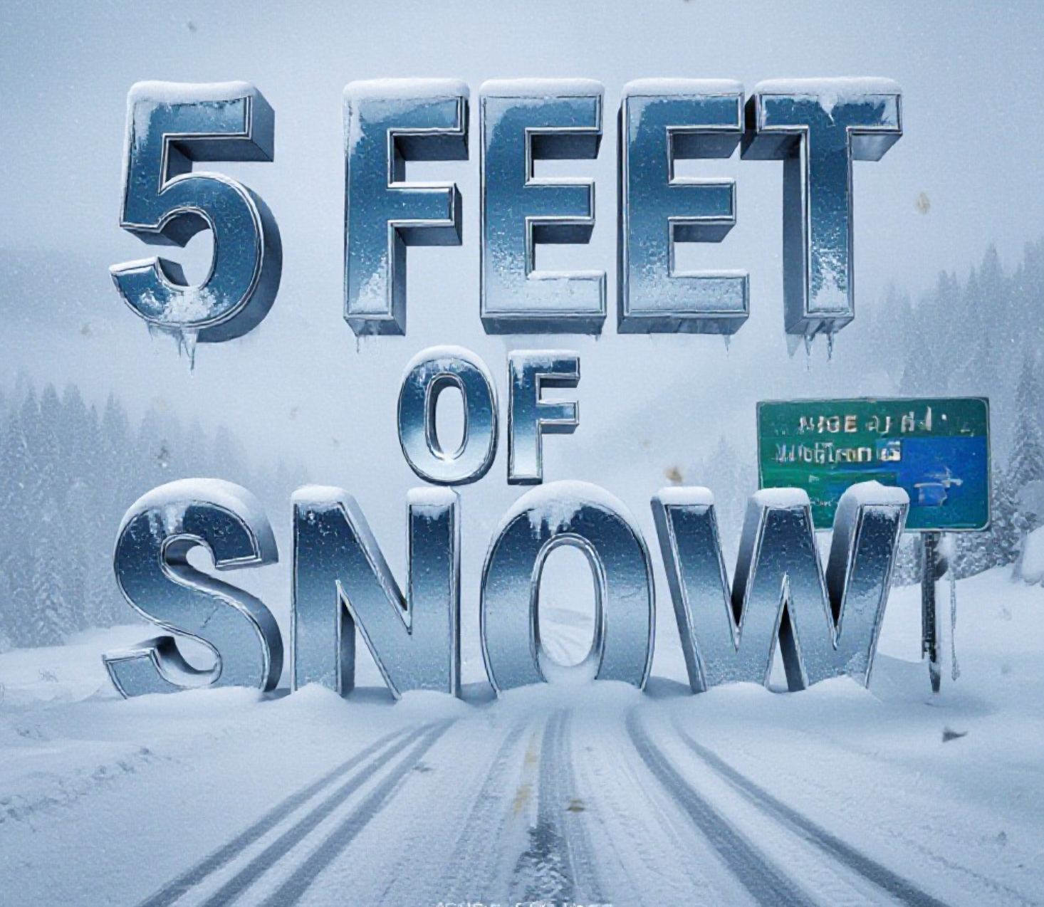
Colorado Mountains Brace for Monster Snowstorm and Avalanche Danger
Grand Junction, Colo. – A powerful spring storm is slamming western Colorado right now, dumping feet of snow in the high country and triggering multiple Winter Storm Warnings, High Wind warnings, and a rare Avalanche Warning for the Elk Mountains. The National Weather Service says some areas could see up to five feet of snow by Friday night, creating life-threatening conditions for anyone in the backcountry.
The heaviest snow is falling right now across the central and southern mountains, with Winter Storm Warnings in effect until 5 a.m. Thursday. The warning covers the Grand Mesa, Elk Mountains, San Juan Mountains, Park Range, Flat Tops, Gore Range, and most passes from Vail to Wolf Creek. Forecasters expect 10-20 inches widespread, with isolated totals topping 40-60 inches in favored spots like Crested Butte, Marble, and Wolf Creek Pass.
Where the Snow Will Hit Hardest
The latest model runs and spotter reports show these zones getting buried:
- Elk Mountains (Aspen, Crested Butte, Marble): 3-4 feet possible, locally higher
- San Juan Mountains (Telluride, Silverton, Wolf Creek Pass): 2-5 feet
- Grand Mesa summit: up to 2+ feet
- Vail Pass, Monarch Pass, Red Mountain Pass: 18-30 inches
- Continental Divide north of I-70: 8-18 inches
- Four Corners region (Durango, Cortez): 6-12 inches of heavy, wet snow
Lower valleys along I-70 and Highway 50 will mostly see rain turning to slushy snow Thursday night into Friday, with 1-4 inches possible around Grand Junction, Delta, and Montrose.
Winds Are Making It Worse
A Wind Advisory is up until 5 p.m. Wednesday for the entire Western Slope. Gusts have already hit 69 mph in Moab and 68 mph in Rifle Tuesday, and forecasters say 50-70 mph gusts will continue through the day. These winds will create areas of near-zero visibility in blowing snow and could bring down tree limbs and power lines in the valleys.
Avalanche Danger Hits Level 4 – “Large and Deadly Slides Likely”
The Colorado Avalanche Information Center has issued an Avalanche Warning for the Elk Mountains and an Avalanche Watch for most other zones. Danger is rated HIGH (level 4 out of 5). Natural and human-triggered avalanches are likely on slopes steeper than 30 degrees.
Travel in the backcountry is strongly discouraged. Even popular ski areas are closing upper lifts and doing aggressive avalanche control work. One slide already ran naturally near Crested Butte Tuesday night, and experts say the risk will stay elevated through Friday.
Travel Will Be Brutal Through Friday
CDOT crews are working around the clock, but many high passes will see periods of closure or extreme delays:
- Red Mountain Pass, Coal Bank Pass, Lizard Head Pass: likely closed at times
- Monarch Pass: heavy snow and 60+ mph gusts
- Vail Pass and Eisenhower Tunnel: chain laws and safety closures expected
- I-70 west of Denver: heavy snow north of the highway Thursday night-Friday
If you must travel, carry extra food, water, blankets, and a full charge on your phone. Mountain travel could become impossible Wednesday afternoon through Thursday morning.
The storm finally pushes out Friday night. Sunshine returns this weekend with highs rebounding into the 50s in the valleys by Sunday.
This late-season blockbuster is a stark reminder that winter isn’t done with Colorado yet. Skiers and riders are celebrating the massive refresh, but the danger is real for anyone venturing into the high country. Stay safe out there, check CDOT and CAIC updates before you go anywhere, and let’s hope everyone makes it through this one without tragedy.
What’s your plan for the storm? Are you stuck at home or chasing powder? Drop your thoughts below and tag #COwx if you’re posting photos – just stay out of avalanche terrain.


MapLight Stock Plunges After Schizophrenia Trial Splits on Dosage

Starship Survives Its Splashdown, Clearing SpaceX’s Path to a Historic Catch

Red Cross Declares Second-Ever Blood Crisis as Donors Age Out

FDA Advisers Back Six Peptides but Gray Market Endures

Sandisk and ASML Shares Sink as China Ships Chip Tools

Maple Leaf Bacon Recall Exposes a Border Checkpoint Pattern

Mamdani’s 30% Grocery Discount Plan Alarms NYC’s Bodega Owners

Levothyroxine Recall Leaves Millions to Catch the Risk Themselves

Cyclospora Fears Push Americans Toward the Processed Foods RFK Jr. Opposes

Ford’s Custom Garage Push Bets Big on Owning the Aftermarket

Pokémon GO Developer Niantic Rebrands as Scopely Explore

Persona 4 Revival Hands All Anime Cutscenes to Studio MAPPA

Jaylen Brown Traded to 76ers for Paul George and Four Draft Picks

Doom Studio id Software Cuts Half Its Staff in Xbox Layoffs

Nintendo Switch Online Adds Four Classics and One Japan-Only Title

Jordan Henderson Hospitalized After Wrist Injury at the Azteca

Mexico’s World Cup Run Ends at Azteca as England Hold On 3-2

Meta’s Muse Image Lets Anyone Use Your Instagram Photos in AI

Louis Vuitton Beats Molly Tea in China, Triggers Cultural Backlash

Pink Bearista Cup Returns July 13 as Starbucks Pink Vibes Drops
-

 TECHNOLOGY3 years ago
How to Adjust a Bulova Watch Band – An Easy Guide
-

 News3 years ago
Fred Pentland: Athletic Bilbao’s English mentor who changed the essence of Spanish football
-

 FINANCE3 years ago
Tax Planning for Every Season: Guide to Maximizing Your Tax Benefits
-

 Education3 years ago
African Ministers New Education Plan
-

 BUSINESS3 years ago
What is Entrepreneurial Operating System? A Comprehensive Guide to EOS
-

 Education3 years ago
Innovate Your Learning Journey with Technology and Enhance Education
-

 News3 years ago
Russians formally out of World Athletics Championships
-

 BUSINESS3 years ago
Top 9 Most Expensive American Cities to Rent an Apartment