As rain skirts the valleys and gusts build across the highlands, wildfire smoke and a looming Fire Weather Watch raise new concerns for Western Colorado.
Midweek Weather Disruption Brings Gusts, Showers—and Hazy Skies
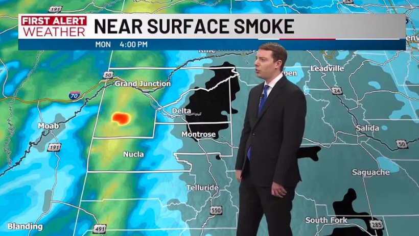
GRAND JUNCTION, Colo. — From lightning in Montrose to smoke drifting from out-of-state wildfires, Western Colorado is entering another stretch of unstable summer weather—marked more by movement than intensity.
While the storm system sweeping through the region today is expected to bring scattered showers and valley gusts, meteorologists say the bigger story lies in tomorrow’s fire risk and the smoke-filled skies that have settled across the Western Slope.
“This is a dynamic pattern,” said a forecaster with the National Weather Service in Grand Junction. “We’ve got moisture trying to push in, but the underlying dryness and smoke transport are still dominating the environment.”
What to Expect Today
Weather conditions for Wednesday remain relatively mild in terms of storm strength, but still bring variability across the region.
-
Rainfall begins near noon over the San Juan Mountains
-
Showers spread to lower valleys by afternoon
-
Grand Junction and Cortez may see brief, light showers
-
Delta and Montrose may encounter isolated thunderstorms
-
Gusts of 20 mph expected in valleys
While cloud cover and occasional lightning may accompany some of these passing showers, heavy rainfall is not expected, limiting the storms’ ability to dampen fire-prone vegetation.
Tomorrow: Fire Weather Watch in Effect
Looking ahead to Thursday, conditions take a more dangerous turn. A Fire Weather Watch has been issued for Moffat and Rio Blanco Counties, beginning at noon Thursday and lasting into the evening.
🔥 Fire Weather Watch Highlights:
-
Sustained winds: 10–20 mph
-
Peak gusts: Up to 30 mph
-
Relative humidity: 6–11%
-
Fire potential: High to critical
When combined with hot temperatures and extended drought conditions, these ingredients could set the stage for rapid ignition and spread of new wildfires.
“It’s a volatile setup,” said one official with the Colorado Division of Fire Prevention and Control. “The winds aren’t extreme, but the dryness and heat are just waiting for a spark.”
Hazy Skies: Smoke Not Local
While parts of Western Colorado are currently under low visibility and diminished air quality, the wildfire smoke blanketing the region is largely imported—carried in by upper-level winds from fires burning in other states.
| Region Affected | Primary Impact | Smoke Source |
|---|---|---|
| Grand Junction | Light haze, mild irritation | Out-of-state wildfires |
| Delta & Montrose | Poor visibility, dry gusts | Regional transport via wind |
| Moffat & Rio Blanco | Dry air, high fire risk | Incoming smoke & dry fronts |
Air quality advisories have not yet been issued, but health officials encourage residents—especially those with respiratory conditions—to monitor air quality indices and limit outdoor activity if smoke thickens.
Storm Outlook: Continental Divide Gets the Worst
While most valley towns will experience minimal rain, the Continental Divide is expected to receive the heaviest precipitation and wind activity today.
That’s good news for higher-elevation wildfire mitigation—but does little to relieve parched valley floors like those near Cortez, Craig, and Meeker.