Crews fighting six major wildfires across Western Colorado made steady gains this weekend, but the danger is far from over with thousands of acres still burning and key roads closed.
Containment numbers climbed in most active fire zones as of Sunday night, July 20, giving firefighters some breathing room after a tense, smoke-choked week. From Turner Gulch to South Rim, residents, officials, and volunteers are keeping eyes peeled — and gear ready — as containment lines hold… for now.
Slow but steady progress across fire zones
There’s cautious optimism in Grand Junction, Gunnison, and neighboring counties as fire crews finally got the upper hand — if only slightly — after battling intense blazes for nearly a week.
Six wildfires continue to smolder in Western Colorado:
-
Turner Gulch: 15,737 acres burned, 34% contained
-
Wright Draw: 466 acres, 51% contained
-
Cottonwood Flat: 310 acres, 35% contained
-
Sowbelly: 2,274 acres, 66% contained
-
South Rim: 4,220 acres, 31% contained
-
Deer Creek: 17,123 acres, 30% contained
The table below breaks down the official figures as of the latest updates Sunday evening:
| Fire Name | Acreage Burned | Containment | Last Update |
|---|---|---|---|
| Turner Gulch | 15,737 acres | 34% | 8:30 p.m., July 20 |
| Wright Draw | 466 acres | 51% | 8:30 p.m., July 20 |
| Cottonwood Flat | 310 acres | 35% | 4:30 p.m., July 19 |
| Sowbelly | 2,274 acres | 66% | 5:30 p.m., July 20 |
| South Rim | 4,220 acres | 31% | 8:00 p.m., July 20 |
| Deer Creek | 17,123 acres | 30% | 8:30 p.m., July 20 |
Some fires are behaving better than expected. Sowbelly, for example, is now more than halfway contained. That’s a rare bright spot in an otherwise brutal wildfire season.
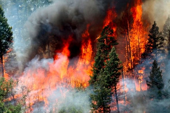
Turner Gulch and Deer Creek: The biggest beasts
Two of the largest fires — Turner Gulch and Deer Creek — are proving stubborn.
Turner Gulch is now 34% contained. That might sound like good news, but at over 15,700 acres, it’s still chewing through remote stretches of forest and backcountry roads near Highway 141.
Firefighters have issued pre-evacuation warnings along Highway 141 between Mile Markers 121 and 138.
One-sentence update: The fire remains unpredictable.
Deer Creek is even larger, burning over 17,000 acres. Containment remains at just 30%.
And it’s not just flames causing problems — heavy smoke and heat continue to wear down firefighters rotating in from across the region.
South Rim: Water reopens, but the threat’s not over
As of 3 p.m. Sunday, one big sigh of relief came through Gunnison County — Blue Mesa Reservoir reopened to water activities.
Still, don’t let the paddleboards and kayaks fool you.
Evacuation orders remain in effect for residents on M73, N73, N74, and O74 roads. Warnings are also in place for areas on the Northern Rim of the Black Canyon of the Gunnison.
And Highway 347? Still closed. No reopening timeline yet.
Even with improved conditions, South Rim is only 31% contained. The terrain is tricky, and winds haven’t exactly played nice.
Evacuations thin out — but not gone yet
Over the weekend, the Clifton Community Center, which had served as an evacuation site, officially shut down operations on July 18.
But this doesn’t mean every family is home safe yet.
Residents in affected zones who still need assistance are urged to call the American Red Cross at 1-800-733-2767. That’s still the fastest route to help for displaced folks.
One-sentence reminder: Pre-evacuation is not the same as safety.
Fire officials have been very clear — stay packed, stay alert, and keep listening for updates.
Crews, closures, and caution tape
A patchwork of closures remains in effect. The U.S. Forest Service announced new access restrictions in the Turner Gulch area:
-
From the northern end of National Forest Service Road (NFSR) 402
-
Southeast along the forest boundary
-
To the intersection of County Road 24.4 and NFSR 408
These are remote zones, but they’re key staging areas for suppression efforts. Officials don’t want curious hikers or campers getting caught in the chaos.
Meanwhile, Highway 347 remains impassable. That’s a pain for residents and tourists alike — especially with Black Canyon peak visitation season underway.
Looking ahead: Heat, smoke, and hope
Weather forecasts for the region are mixed. High temperatures and dry winds could cause flare-ups, but there’s a slim chance of scattered showers in some higher elevations by midweek.
No promises, though.
Crews from the Bureau of Land Management, local fire districts, and out-of-state support teams are still rotating through 16-hour shifts. Every bit of progress is hard-earned.
Officials are urging residents not to get complacent. Even small wind shifts could reignite trouble spots and send firelines back toward populated areas.