Grand Junction residents face an incoming storm system that will deliver strong winds rain and mountain snow starting Friday October 3 2025. This weather event will cause a sharp temperature drop of 10 to 15 degrees through Saturday October 4 bringing cooler fall conditions to western Colorado.
The Storm System Approaches
A low pressure system from the southwest heads toward Grand Junction setting the stage for unsettled weather over the weekend. Local forecasts show this disturbance gaining strength as it moves in leading to widespread impacts across the valleys and higher elevations. Experts note that such systems often bring a mix of precipitation types in early October when cooler air masses clash with lingering summer warmth.
The timing aligns with a transition from recent warm days to more typical autumn patterns. Thursday October 2 remains sunny with highs in the low to mid 80s but changes begin early Friday. This shift highlights how quickly weather can evolve in the region due to its position between the Rockies and desert influences.
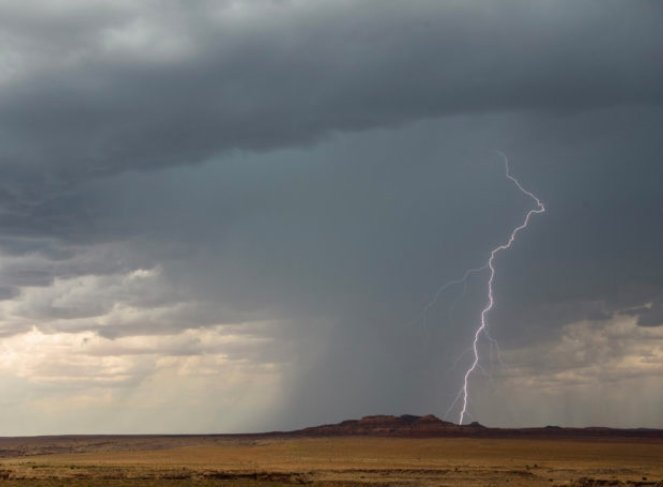
Wind Gusts Take Center Stage First
Winds will ramp up as the primary sign of the storm’s arrival making Friday the starting point for gusty conditions. Expect speeds to build from 20 to 30 miles per hour in the valleys by late morning with peaks through the afternoon. Mountain areas could see even fiercer gusts reaching 40 to 50 miles per hour which might affect travel and outdoor plans.
Overnight into Friday evening winds ease slightly to 15 to 25 miles per hour but Saturday brings a fresh surge. Valleys may experience 30 to 40 miles per hour gusts while mountains face sustained 40 to 50 miles per hour blasts. These conditions stem from the storm’s front pushing through and could lead to minor disruptions like power flickers or debris on roads.
Recent similar events in the area remind us of the potential for stronger localized winds. For instance a comparable system last fall caused brief outages in nearby communities underscoring the need for vigilance.
Rain and Snow Mix in the Forecast
Rain becomes the main feature on Saturday with steady showers arriving between 6 a.m. and noon across Grand Junction and surrounding spots. Amounts could total a quarter to half an inch in the valleys though some areas might see less if the system tracks slightly off course. Mountains will likely get heavier totals boosting moisture in higher terrain.
A few early showers might pop up Friday afternoon mainly over elevated areas but the bulk holds off until Saturday. By afternoon and evening occasional rain lingers in valleys while mountains transition to a rain snow mix along the Continental Divide. Snow accumulation remains light at a few inches in the highest peaks but could create slick spots for hikers or drivers.
This precipitation pattern fits broader trends for October in western Colorado where early storms help replenish water supplies after dry summers. Logical reasoning suggests the rain will benefit local agriculture by easing drought concerns though sudden downpours raise flash flood risks in dry washes.
- Key precipitation highlights include widespread valley rain on Saturday morning.
- Mountain snow possible in the afternoon with light accumulations.
- Total rainfall estimates range from 0.25 to 0.50 inches in lower areas.
- Higher elevations may see up to 1 inch of rain equivalent before snow.
Temperature Drop Signals Fall Arrival
The storm ushers in a noticeable chill with temperatures falling 10 to 15 degrees by Saturday afternoon. Friday highs push into the mid 80s under partly cloudy skies but Saturday caps out in the upper 60s to low 70s. This drop follows the cold front’s passage marking a classic seasonal change.
Mornings cool further with lows dipping into the 30s and 40s by Sunday October 5 potentially leading to the area’s first frost. Such swings are common in Grand Junction where elevation and proximity to mountains amplify contrasts. Residents should prepare for layered clothing as daytime warmth fades quickly after sunset.
| Day | High Temperature | Low Temperature | Conditions |
|---|---|---|---|
| Thursday Oct 2 | 82-85°F | 53°F | Sunny and warm |
| Friday Oct 3 | 85-88°F | 55°F | Windy with possible showers |
| Saturday Oct 4 | 68-72°F | 51°F | Rainy and cooler |
| Sunday Oct 5 | 65-70°F | 35-40°F | Partly cloudy with frost risk |
This table outlines the expected shifts helping readers plan their week around the changing climate.
Potential Impacts and Safety Tips
Strong winds pose the biggest risk for travel especially on highways like Interstate 70 where gusts could sway vehicles. Rain may cause minor ponding on roads and increase slipperiness while mountain snow adds hazards for backcountry users. No major advisories stand yet but monitors watch for updates as the system develops.
Local authorities advise securing outdoor items and avoiding high profiles on the road during peak winds. Farmers and gardeners should protect sensitive plants from the frost threat. Drawing from past events like a windy October storm in 2023 that downed trees this one calls for proactive measures to minimize damage.
The emotional toll of sudden weather changes can affect daily routines so staying informed brings peace of mind. Practical steps like checking forecasts twice daily solve potential problems before they arise.
Looking Ahead After the Storm
By Sunday the system moves out leaving behind clearer skies and seasonal temperatures. Early next week looks dry with highs rebounding to the 70s offering a return to mild fall weather. This brief storm fits into a pattern of variable October conditions influenced by Pacific patterns.
Longer term outlooks suggest above average precipitation for the month aiding reservoirs but also hint at more active weather ahead. Residents can use this event as a reminder to review emergency kits for the cooler months.
Stay updated on local forecasts and share your storm experiences in the comments below. Your insights help the community prepare better together.