After a week of hit-or-miss downpours, rumbling skies, and smoky haze, Grand Junction and much of Western Colorado are set to dry out—just in time for the weekend.
Scattered showers and thunderstorms will begin fading late Friday, with Saturday marking a noticeable shift toward calmer skies and rising temperatures. But don’t put the umbrella away just yet; pockets of rain and lingering smoke may still hang around.
Friday Brings Final Act of Storm Pattern
The tail end of this unstable stretch will feature scattered rainfall, mostly confined to Friday morning. Showers will begin tapering off around midday, especially in the valleys. Higher elevations—particularly the mountains—could still catch a few afternoon downpours, but the trend is clear: less rain, more dry patches.
By nightfall Friday, storm activity should wind down completely.
One line from the National Weather Service sums it up well: “We’ll not all get the rain, but where it falls, it may fall hard.”
And that’s the thing—these storms have been spotty. Some neighborhoods got drenched. Others stayed bone dry.
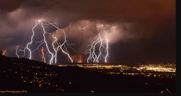
Be Smart About Lightning—It Travels
Thunderstorms aren’t just about rain. The real threat has been lightning, especially in wide open spaces like the Colorado Plateau and valley trails.
Meteorologist Stephen Bowers issued a reminder that lightning can strike well outside a visible storm cell—sometimes up to 30 miles away. It doesn’t even have to be raining where you are.
Here’s what locals need to remember:
-
If you hear thunder, you’re within striking range.
-
Wait at least 30 minutes after the last thunderclap before going back outside.
-
Even light showers can be paired with dangerous electrical activity.
Small hail and heavy bursts of rain have also been reported throughout the week, particularly in areas east of Grand Junction and into the Uncompahgre foothills.
Smoky Skies May Linger—But Not As Thick
Air quality has been a mixed bag lately, thanks to wildfires burning from central Utah to northern Arizona. While smoke levels have improved in recent days, it’s not completely gone.
You may still smell it or notice haze—especially in the valleys and along ridge lines like the Uncompahgre Plateau. The movement is unpredictable; one hour it’s fine, the next it feels like a campfire just blew through.
On Friday and Saturday, expect occasional smoke to continue drifting into the region. Thicker plumes may cling to mountain areas overnight.
And here’s the key health note: If visibility drops below five miles due to smoke, the air is considered unhealthy—especially for kids, seniors, and those with lung conditions.
Weekend Outlook: Looking Up
Things really start to turn by Saturday.
Rain chances drop to near zero in most valleys. A stray thunderstorm in the mountains? Possible, but not likely to bring widespread disruption. Sunday follows suit—dry, a bit warmer, and maybe even… calm?
Here’s a rough snapshot of what to expect:
| Day | Rain Chance | Daytime High | Notes |
|---|---|---|---|
| Friday | Moderate (esp. AM) | Low 80s | Spot showers early, clearing late |
| Saturday | Low | Mid 80s | Slight chance of mountain storm |
| Sunday | None | Upper 80s | Drier and warmer overall |
You’ll feel the warmth building again by Sunday, especially in sun-exposed areas. The chillier and wetter moments from earlier this week will feel like a memory.
A Note of Caution
Just because the storms are fading doesn’t mean all is clear. Visibility might still shift due to smoke. And rapid weather changes are still possible, especially at higher elevations.
So if you’re headed outdoors for a hike or planning a float trip on the Colorado River, keep an eye on conditions—and your phone’s weather app.
One small cell forming over the Book Cliffs could mean a quick soaker or a lightning risk.