Firefighters battle rough terrain and shifting winds as U.S. Forest Service tightens restrictions in the Uncompahgre
Officials aren’t taking any chances. As the Turner Gulch Fire continues to chew through rugged land in western Colorado, authorities have expanded forest closures in Mesa County, citing ongoing fire activity, tricky topography, and the potential for rapid flare-ups.
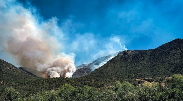
The fire has been burning since July 10. Now nearly two weeks in, it’s already torched over 15,400 acres — and despite aggressive firefighting, it’s only 34% contained. That’s prompted the U.S. Forest Service to widen its closure order, effectively sealing off much of the land between Divide Road and Highway 141.
New Closure Map Redraws Access Boundaries
The newly expanded closure area follows a jagged path through some of the most remote sections of the Uncompahgre Plateau. For residents and recreationists alike, the update matters.
The Forest Service laid it out like this: The closure begins at the northern end of National Forest System Road 402 (Divide Road), sweeping southeast along the forest’s edge to County Road 24.4 and NFSR 408. From there, it curls southwest along NFSR 408 until looping back via NFSR 402.
That’s not all. The restricted zone then follows National Forest System Trail 620 west, hitting Blue Creek, and pushing toward the far western edge of the forest boundary.
Everything north of that zone and south of Highway 141? Off-limits.
This isn’t a small patch of land. It’s a major chunk of the western slope — a popular playground for off-roaders, hikers, and hunters. The closures have upended plenty of summer plans.
Why Containment Is So Tricky This Time
Containment lines are holding — for now — but the situation is fragile.
Steep ridgelines, shifting winds, and dry fuels are complicating every move. Even with air tankers and ground crews working in tandem, the terrain itself makes progress slow. Some days, it’s two steps forward, one step back.
“This fire isn’t behaving,” one local firefighter said off-record. “We get a handle on one flank, and then the wind changes. It’s just that kind of season.”
And it’s not just wind. Temperatures have been hovering in the upper 90s. Afternoon thunderstorms — often dry — keep sparking spot fires beyond the primary containment lines.
It’s a mess.
What’s Closed and What’s Still Open?
If you’re planning a trip to the area, here’s what you should know before loading the truck:
-
Closed: All National Forest System lands within the revised perimeter — including access roads, trailheads, and dispersed campsites.
-
Still Open: Lands north of Highway 141 remain accessible, though officials warn smoke and firefighting equipment could still be in the area.
The Bureau of Land Management (BLM) is also urging caution for nearby federal lands not technically under closure. They’re not restricted — yet — but it’s clear everyone’s watching closely.
Local Communities on Edge, but Resilient
Delta County and Mesa County residents are no strangers to fire season. But Turner Gulch feels different. It’s bigger, hotter, and closer than some would like.
In Gateway and Whitewater, locals are monitoring conditions constantly. Radio chatter is nonstop. Air support thunders overhead most afternoons. There’s a shared unease — but also grit.
One rancher near Unaweep Canyon said they’ve been sleeping with boots by the bed. Just in case.
“Had to move the cattle out two days ago. You don’t wait till the flames are licking the fence line,” he told us while refueling at a roadside station. “We’ve seen it before, but this one’s pushing it.”
Fighting the Fire: Crews, Costs, and Progress So Far
Fire officials say over 300 personnel are now assigned to the Turner Gulch blaze. Crews from Colorado, Utah, and as far away as New Mexico have joined the fight.
A snapshot of resources deployed:
| Resource Type | Number Deployed |
|---|---|
| Fire Engines | 25 |
| Helicopters | 7 |
| Bulldozers | 9 |
| Hand Crews | 12 |
| Water Tenders | 15 |
There’s no official cost estimate yet, but fires of this scale can easily run into the tens of millions. And that’s before calculating the economic impact of closures on local tourism, hunting, and forestry operations.
What’s Next? Waiting, Watching, and Weather
For now, all eyes are on the skies — and the weather apps.
The National Weather Service says there’s a slim chance of moisture in the coming days. But it’s tricky. Too little rain won’t help, and too much lightning could make things worse.
Meanwhile, fire behavior analysts are watching fuel moisture levels and modeling spread scenarios. It’s a daily game of recalculating.
There’s cautious optimism that more containment will come this week. But no promises.
One thing is clear: officials aren’t waiting for things to get worse. They’ve drawn the line — literally — to keep people safe.