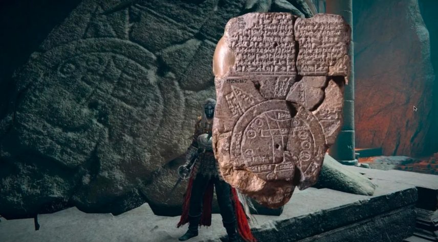
Researchers from the British Museum have unveiled a new interpretation of the Imago Mundi, a 3,000-year-old Babylonian clay tablet believed to be the oldest world map. This ancient artifact, dating back to the seventh century B.C.E., has fascinated archaeologists for over a century. Depicting Mesopotamian geography with the Euphrates River at its core, the map also features neighboring cities, mountains, and waters, representing how the Babylonians envisioned their world.
In a surprising revelation, recent translations of additional inscriptions on the tablet hint at the possible location of an ark in a flood narrative similar to the Biblical story of Noah.
Deciphering the Imago Mundi
The Imago Mundi was discovered in the late 19th century in southern Iraq, near the site of ancient Babylon. Upon acquisition by the British Museum in 1882, researchers identified it as the world’s oldest known map, depicting Babylonian territory. The tablet’s engravings, crafted in cuneiform script, capture a worldview where the Euphrates flows through the center of the map, encircled by various Mesopotamian cities and landmarks.

The “Bitter River” and the World Beyond
A unique aspect of the Imago Mundi is its outer ring, known as the “Bitter River,” which surrounds the Babylonian world as understood by its creators. Everything beyond this boundary was considered unexplored, mysterious terrain. Triangular shapes carved into this outer section likely represent far-off mountains or unknown regions, places that were beyond the reach of ancient Mesopotamian explorers.
Recent Discoveries on the Tablet
Dr. Irving Finkel, a curator and cuneiform expert at the British Museum, recently presented new findings related to the tablet in a video update. “You have encapsulated in this circular diagram the whole of the known world in which people lived, flourished, and died. However, there’s more to this map than that,” he stated, hinting at intriguing new discoveries.
Unveiling the Connection to Noah’s Ark
Researchers have now translated previously obscure cuneiform inscriptions, finding references to Utnapishtim, a king within Babylonian mythology who constructed a massive ark to survive a world-destroying flood. Utnapishtim’s story, preserved in the Epic of Gilgamesh, bears notable similarities to the Biblical account of Noah and his ark. According to the Epic, the god Marduk commanded Utnapishtim to build the ark, ensuring the survival of humanity in the face of a divine flood.
In the new translation, researchers noted additional details regarding Utnapishtim’s ark and its location following the flood, with hints that may lead to its resting place. This information has ignited a fresh wave of interest among scholars, many of whom are intrigued by the potential connection between the Imago Mundi and the Biblical narrative.
Historical Significance of the Imago Mundi
The Imago Mundi has long been an essential artifact for understanding ancient worldviews. It captures not only geographical details but also the cosmological beliefs held by Babylonians over 2,000 years ago. While many other flood myths from various cultures exist, the Imago Mundi’s connection to both Marduk and Utnapishtim lends significant weight to its importance.
How the Tablet Fits into the Broader Picture
This artifact offers a glimpse into how the Babylonians structured their understanding of the world. The double-ringed map shows a balance between earthly geography and cosmological beliefs, demonstrating that their worldview encompassed both tangible and mythical realms. Unlike modern maps that delineate borders and territories, the Imago Mundi was more symbolic, representing known and unknown worlds alike. The recent discovery of potential ark-related inscriptions adds a compelling spiritual dimension to this ancient map.
A Unique Intersection of Myth and Cartography
The newly translated inscriptions highlight the interconnectedness of geography and mythology in ancient Mesopotamia. The possibility that the tablet references a location for Noah’s ark, or an ark-like structure, is of interest not only to archaeologists but also to religious scholars who study cross-cultural flood myths. This new interpretation of the Imago Mundi tablet demonstrates that early civilizations may have used maps not only to depict their physical surroundings but also to record spiritual and mythological knowledge.
As researchers continue to study the Imago Mundi, they hope to uncover additional insights that may further reveal how ancient peoples saw and interpreted their world. For now, the discovery adds a captivating chapter to the ongoing story of humanity’s search for understanding within the realms of history, myth, and cartography.
Category: Archaeology / Ancient Texts
Meta Description: New findings on the 3,000-year-old Imago Mundi tablet suggest it may contain clues to Noah’s Ark’s location, blending myth and ancient Babylonian geography.
URL Slug: worlds-oldest-map-noahs-ark-location
Image Keywords: Imago Mundi tablet, Babylonian map, Noah’s Ark, ancient Mesopotamian artifacts


