News
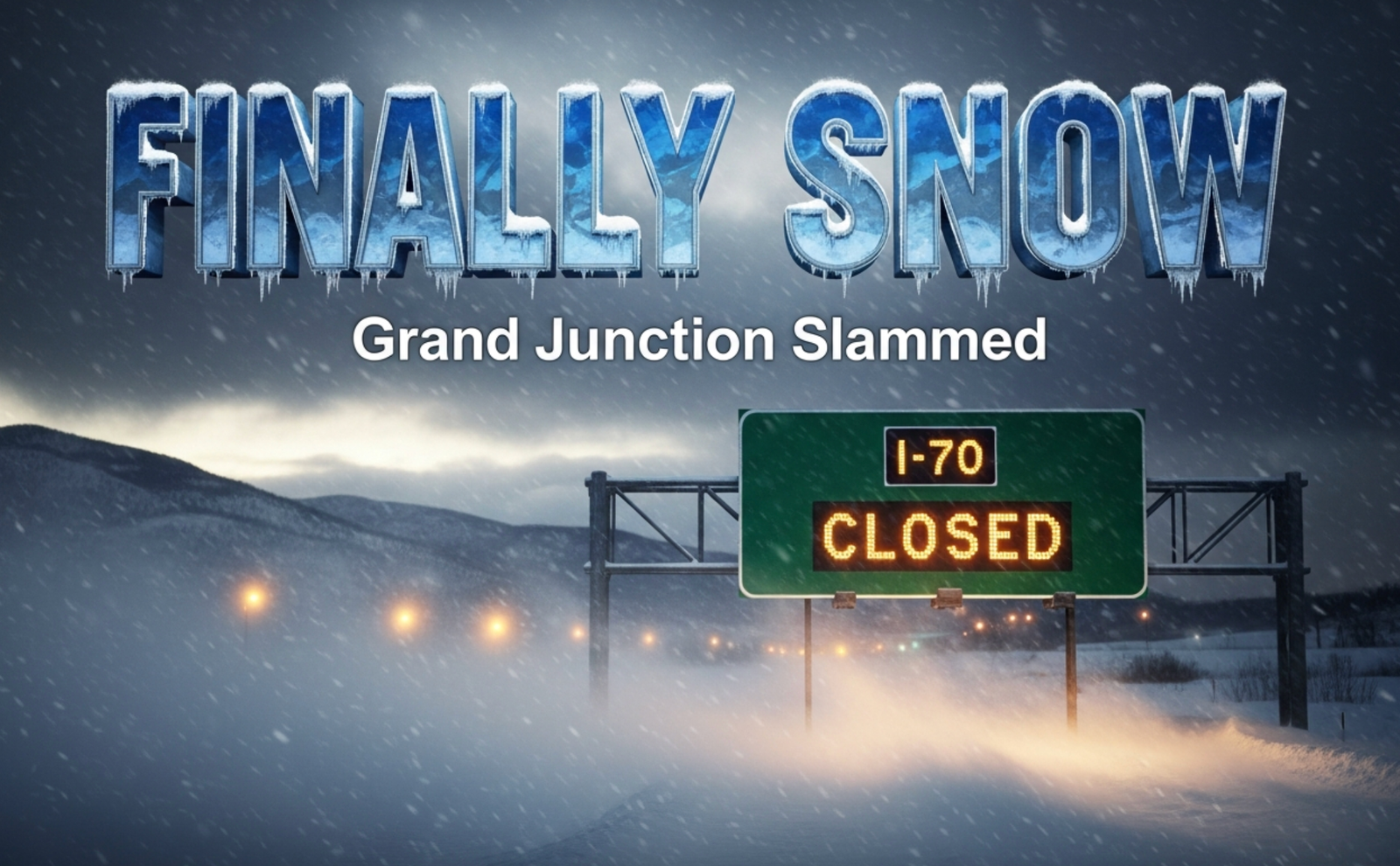
Western Colorado Braces for Major Winter Storm: Rain and Heavy Snow Set to Slam Region Next Week
After weeks of unusually mild and bone-dry weather, a powerful storm system is finally taking aim at Western Colorado, with rain and mountain snow arriving Tuesday and potentially heavy snow hitting the valleys by Wednesday.
The National Weather Service and Climate Prediction Center have both flagged February 11-17 as having an elevated risk of significant snowfall across much of the state, and the latest model runs show the Grand Valley, Montrose, Delta, Cortez, and the San Juans all in the crosshairs.
Dry and Mild Weekend Gives Way to Big Changes
Enjoy the sunshine while it lasts.
Friday through Monday will remain dry with highs climbing into the mid-to-upper 50s across the Grand Valley and Delta areas, and even touching near 60 degrees in Moab and Cortez this weekend. Morning lows will stay in the upper 20s to low 30s, making it feel more like early April than early February.
This is the calm before the storm.
Storm System Arrives Tuesday – Snow Could Pile Up Fast
The pattern flip begins Tuesday afternoon as a strong low-pressure system dives southeast out of the Pacific Northwest.
Current forecasts show:
- Rain starting in the lower valleys Tuesday afternoon and evening
- Steady snow developing in the mountains above 6,500 feet by Tuesday night
- Cold air wrapping in Wednesday morning, potentially changing rain to snow even in Grand Junction, Montrose, and Delta
- Highest snowfall totals expected in the San Juans, San Miguel, West Elk, and Park ranges (12-24 inches possible above 8,000 feet)
- 3-8 inches possible down to the valley floors if the cold air arrives on schedule
The National Weather Service office in Grand Junction stressed Wednesday morning could bring the first meaningful valley snow since early January.
Travel Impacts Expected Across Mountain Passes
If you’re planning to drive I-70, Highway 50, or any mountain route Tuesday night through Wednesday, prepare for major delays or closures.
Monarch Pass, Wolf Creek Pass, Red Mountain Pass, and Vail Pass are all likely to see heavy snow and strong winds Wednesday, with blizzard conditions possible in the higher terrain.
CDOT is already pre-treating roads and putting crews on 12-hour shifts starting Monday night.
How Much Snow Will Grand Junction Actually Get?
It’s still a close call for the lower valleys.
The European model is colder and brings 4-7 inches to Grand Junction and Montrose.
The American GFS model is milder and keeps most precipitation as rain with only a dusting to 2 inches of slop.
Right now, forecasters are leaning toward the colder solution, which would give the Grand Valley its biggest snow event of the season so far.
One thing is certain: temperatures will crash behind the front. Highs on Thursday and Friday may struggle to reach the mid-30s, with overnight lows dropping into the teens by late next week.
The last time Grand Junction saw a storm of this magnitude in February was 2019, when 18.2 inches fell over three days and shut down schools and roads for nearly a week.
Western Colorado has been in a snow drought all winter. Montrose is running 60% below normal snowfall, and Telluride is at just 48% of average. Ski resorts, farmers, and water managers are all watching this storm with desperate hope.
This could be the shot in the arm the high country desperately needs before spring runoff season begins.
Stay with us as we track every new model run. We’ll have hour-by-hour updates starting Sunday night and live coverage when the storm arrives Tuesday.
What do you think, will this finally be the big one we’ve been waiting for all winter? Drop your guess for Grand Junction snowfall in the comments below and tag your friends who still don’t believe snow is coming. #WesternColoradoStorm #FinallySnow


Geekbench 7 Launches and Erases Three Years of Scores

Google’s Selfie Video Sign-In Arrives as Deepfake Fraud Surges

Samsung’s New Galaxy Z Fold 8 Undercuts Its Own Ultra

Kroger and Brookshire’s Recall Over 19 Million Eggs for Salmonella

Mortgage Rates Hit an 11-Month High as Oil Fears Bite

Oil’s Price Shock Collides With Wall Street’s AI Spending Boom

Parsley and Cilantro Emerge as Cyclospora Suspects in North Carolina

Walmart Dresser Recall Reveals a Wider Furniture Safety Sweep

Apple’s iOS 27 Speed Fixes Echo Its 2018 Playbook

Cheshire Medical Center Cyclospora Cluster Exposes a Wider Outbreak

Pokémon GO Developer Niantic Rebrands as Scopely Explore

Persona 4 Revival Hands All Anime Cutscenes to Studio MAPPA

Doom Studio id Software Cuts Half Its Staff in Xbox Layoffs

Jaylen Brown Traded to 76ers for Paul George and Four Draft Picks

Nintendo Switch Online Adds Four Classics and One Japan-Only Title

Jordan Henderson Hospitalized After Wrist Injury at the Azteca

Mexico’s World Cup Run Ends at Azteca as England Hold On 3-2

Meta’s Muse Image Lets Anyone Use Your Instagram Photos in AI

Louis Vuitton Beats Molly Tea in China, Triggers Cultural Backlash

Pink Bearista Cup Returns July 13 as Starbucks Pink Vibes Drops
-

 TECHNOLOGY3 years ago
How to Adjust a Bulova Watch Band – An Easy Guide
-

 News3 years ago
Fred Pentland: Athletic Bilbao’s English mentor who changed the essence of Spanish football
-

 FINANCE3 years ago
Tax Planning for Every Season: Guide to Maximizing Your Tax Benefits
-

 Education3 years ago
African Ministers New Education Plan
-

 BUSINESS3 years ago
What is Entrepreneurial Operating System? A Comprehensive Guide to EOS
-

 Education3 years ago
Innovate Your Learning Journey with Technology and Enhance Education
-

 News3 years ago
Russians formally out of World Athletics Championships
-

 BUSINESS3 years ago
Top 9 Most Expensive American Cities to Rent an Apartment