Grand Junction, Colorado, faces ongoing winter weather as a storm system drops snow across the region, with mountain areas seeing up to 10 inches by Monday morning. Officials warn of slippery roads and travel hazards, urging residents to stay alert as the snow tapers off but more could follow midweek.
Current Storm Impact in Western Colorado
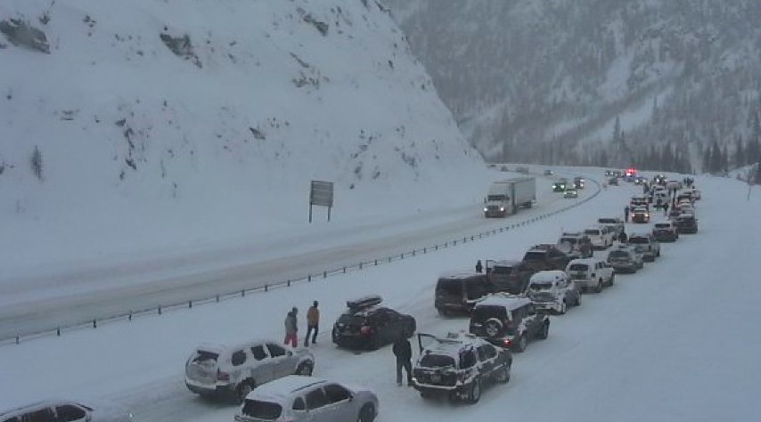
Snowfall started Sunday and continued into the night, affecting highways like Interstate 70 with closures due to crashes. The National Weather Service issued a Winter Weather Advisory for multiple mountain ranges, including the Grand Mesa and San Juan Mountains, expecting 5 to 10 inches of accumulation.
Valleys around Grand Junction saw lighter snow, with some spots getting just trace amounts. By early Monday, the system moves east, leaving behind cold temperatures in the low 20s overnight. This storm follows a pattern of early winter systems in 2025, similar to the Thanksgiving snowfall that blanketed Denver with its first measurable snow in over 200 days.
Recent data shows this event as part of a colder than average start to December, with precipitation slightly above normal according to long range forecasts.
Expected Snowfall and Clearing Skies
Forecasts predict the snow will fade between 2 a.m. and 6 a.m. Monday in higher elevations, with valleys clearing earlier. Grand Junction could see highs near 39 degrees under partly cloudy skies by afternoon.
Here’s a breakdown of projected snowfall amounts across key areas:
- Valleys like Grand Junction and Delta: Up to 1-2 inches, though many spots may get none.
- Grand Mesa and nearby ranges: Additional 1-2 inches.
- Elk Mountains: 2-6 inches possible.
- San Juan Mountains: 6-12 inches, with isolated peaks reaching 18 inches.
- Central and northern mountains: 1-4 inches, locally up to 8 inches.
This aligns with patterns from recent storms, where southwestern Colorado often sees heavier totals.
A table of temperature expectations for Monday helps illustrate the chill:
| Location | Low Overnight | High Monday |
|---|---|---|
| Grand Junction | 22 degrees | 39 degrees |
| Montrose | 20 degrees | 35 degrees |
| Delta | 20 degrees | 39 degrees |
| Cortez | 19 degrees | 42 degrees |
| Moab | 25 degrees | 42 degrees |
These figures come from updated models showing a quick return to drier conditions.
Mountain passes remain the biggest concern, with blowing snow reducing visibility and creating hazardous drives.
Travel Warnings and Road Conditions
Interstate closures highlight the risks, as slick surfaces lead to accidents. Travelers should check updates before heading out, especially over high passes where snow continues longest.
State patrols report increased calls for assistance, echoing issues from a January 2025 storm that dumped up to a foot in similar areas. Logical precautions include carrying chains and extra supplies for delays.
In valleys, any light snow could refreeze overnight, making morning commutes tricky despite the fade.
Communities like Montrose and Cortez prepare for minor impacts, with schools monitoring for possible delays.
Upcoming Weather Systems on the Horizon
Another storm arrives Tuesday, starting in the northwest and spreading south by evening. Snow could pick up in mountains through Wednesday, with valleys seeing occasional flurries.
This follows a trend of active weather, as seen in November 2025 systems that brought widespread snow to Colorado’s western slopes. Forecasts suggest 3 to 10 inches more in mountains, keeping ski resorts busy but challenging for drivers.
Long term outlooks point to warmer than normal winter overall, but with above average southern snowfall, tying into broader climate shifts observed this year.
Residents should prepare for variable conditions, as cold fronts continue to influence the region.
Safety Tips for Winter Weather
To stay safe, focus on preparation and awareness. Experts recommend simple steps to avoid common pitfalls.
Key advice includes:
- Check tire tread and inflate properly for better grip on icy roads.
- Keep an emergency kit in your vehicle with blankets, water, and a flashlight.
- Avoid unnecessary travel during peak snow hours, especially at night.
- Monitor local alerts through apps or radio for real time changes.
These measures have proven effective in past events, like the February 2025 storm that caused widespread disruptions but fewer incidents where people heeded warnings.
Communities benefit from shared vigilance, reducing strain on emergency services.
Community Response and Outlook
Local officials in Grand Junction praise quick responses from road crews, who worked overnight to clear paths. This storm, while not the season’s worst, reminds everyone of winter’s unpredictability in Colorado.
With more snow possible midweek, the area braces for continued cold. Recent events, such as the Bureau of Land Management’s seasonal closures starting December 1, add layers to outdoor planning.
Overall, the fading snow brings relief, but preparation remains key for what’s ahead.
Share your experiences with this storm in the comments below, and pass this article along to help others stay informed.