News
Colorado Holiday Travel Weather Improves After Rain and Snow
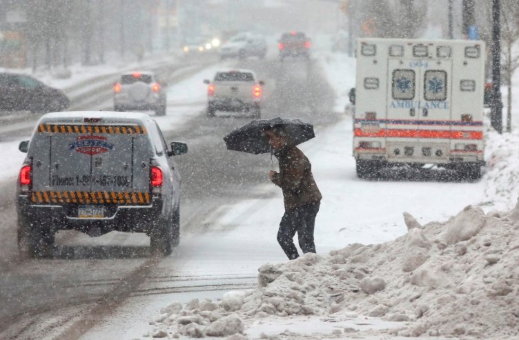
Colorado travelers can expect better conditions as rain and snow move out of the state overnight. With the holiday season approaching, this shift brings relief for those heading out for Thanksgiving, but experts warn of possible new storms later in the week.
Current Weather Conditions Across Colorado
Rain and mountain snow are winding down across Colorado tonight, setting the stage for clearer skies on Monday. A Winter Weather Advisory remains in effect until midnight for the San Juan Mountains, including spots like Telluride and Ouray, where an extra three to six inches of snow could fall and make high passes tricky.
In the valleys, rain is limited and should end before midnight. On the Eastern Plains, any leftover rain will clear out by early Monday morning. Temperatures tonight will drop to the low 30s in many areas, with Grand Junction seeing around 33 degrees and Montrose dipping to 29 degrees.
Monday looks mostly sunny after some morning clouds. Highs will climb to the upper 40s and low 50s across the Western Slope, offering a welcome break from recent wet weather.
Impact on Holiday Travel Plans
The improving weather comes at a key time for Thanksgiving travel, with millions expected on roads and at airports this week. Recent rain and snow have already caused some slowdowns, especially in the mountains and on the Eastern Plains, where slick roads might linger into early Monday.
Air travel could face issues elsewhere as the storm system heads east. Areas around Chicago and Dallas-Fort Worth may see delays on Tuesday, while later impacts could hit Atlanta, Washington, New York, and Boston.
In Colorado, the focus shifts to better driving conditions, but travelers should check for any remaining icy spots. The Colorado Department of Transportation has noted heavy volume in past holiday weekends, and with potential new weather, caution is key.
- Key trouble spots include Highway 550 and parts of Highway 160 in the San Juans.
- Eastern Plains roads may have wet patches until mid-morning Monday.
- Mountain passes like Lizard Head and Coal Bank could see difficult travel due to fresh snow.
Forecast for the Coming Days
Looking ahead, Monday will bring sunshine and milder temperatures, with highs near 52 degrees in Grand Junction and 51 degrees in Moab. This dry spell offers a short window for smooth travel before the next system arrives.
A new storm is expected this weekend, bringing chances of rain in the metro areas and snow in the mountains. Denver is still waiting for its first measurable snow of the season, which has already set records for the latest arrival in 2025.
Long-range outlooks suggest a colder, wetter pattern during the Thanksgiving window from November 23 to 29. Precipitation could include a mix of rain and snow, especially in higher elevations.
Experts predict La Nina conditions will influence winter weather, leading to above-normal temperatures but near-normal snowfall in southern Colorado. Travelers should prepare for variable conditions as the holiday nears.
| City/Area | Monday High | Tuesday Outlook | Weekend Risk |
|---|---|---|---|
| Grand Junction | 52 degrees | Mostly sunny, low 50s | Rain possible Sunday |
| Denver Metro | Upper 40s | Partly cloudy | Snow chances, 4-8 inches possible |
| San Juan Mountains | Low 40s | Clearing skies | Heavy snow, 6-12 inches |
| Eastern Plains | Near 50 degrees | Dry | Mix of rain and snow |
Potential Risks from Upcoming Storms
While the current system exits, another one could affect holiday plans starting Sunday. Models show snow mainly in the southern mountains like the San Juans and Sangre de Cristos, with rain at lower elevations.
This could lead to travel disruptions, including slippery roads and reduced visibility. In Denver, there’s growing agreement on a possible heavy, wet snow event, potentially bringing six inches or more from Friday night into Saturday.
Historical data shows November storms can shut down travel, as seen in past years with blizzard conditions and heavy accumulations. With 2025 marking a late start to snow in Denver, any incoming system might catch drivers off guard.
Travelers heading to ski areas should watch for gusty winds and blowing snow, which have made conditions tough in previous storms.
Tips for Safe Holiday Travel in Colorado
To navigate the changing weather, plan ahead and stay informed. Check road conditions through official apps and websites before setting out.
Pack essentials like blankets, water, and snacks in case of delays. If flying, monitor airport updates for any storm-related issues in connecting cities.
Consider flexible travel times to avoid peak hours, especially on interstates like I-70, where holiday traffic mixes with weather can cause backups.
Share your thoughts on how the weather is affecting your holiday plans in the comments below, and pass this article along to fellow travelers for safer journeys.

Two Teams Build the First Working Thorium-229 Nuclear Clocks

Earliest Flickering Quasar Found 850 Million Years After the Big Bang

Birmingham Physicists Build a 24,000-Atom Mini-Universe to Test Time

Humans Have a Counterclockwise Walking Bias, and It Spans Cultures

Venus Flytrap Snap Solved: Cell Walls Soften, Not Water, Study Finds

The Former SpaceX Welder Whose $10,000 Stock Grant Became $1,046,175

Siri AI Compatible Devices: The Full List and the 12GB Catch

GameStop Pro Points End in 2026, But the $25 Fee Stays

Pokemon Go Player Scans Now Power Military Drone Navigation Tech

New Warhammer 40,000 Event Companions Lock In One Force Disposition

Subnautica 2 Studio Apologises, Holds Line on No-Kill Combat

Brent at $111 Hides the Hormuz Damage Hitting Fed and Asia

Shai Gilgeous-Alexander Wins Second Straight MVP With 83 of 100 First-Place Votes

Mitchell Matches Kobe in Game 7 Rout, Cavaliers Reach East Finals

Xperia 1 VIII Holds Price, Xiaomi 17 Max Loads Up: Week 20 Phone News

Colt Emerson Debuts, Mariners Get Swept by Padres in Vedder Cup

Rousey Finishes Carano in 17 Seconds and Hands Netflix Its MMA Opening

Samsung Strike Looms May 21 as Union Eyes SK Hynix Bonus Formula

Jaylen Brown Calls Stephen A. Smith the Face of Clickbait Media

LIRR Strike Hits Third Day as 250,000 Commuters Face a Tougher Manhattan Run
-

 TECHNOLOGY3 years ago
How to Adjust a Bulova Watch Band – An Easy Guide
-

 News3 years ago
Fred Pentland: Athletic Bilbao’s English mentor who changed the essence of Spanish football
-

 FINANCE3 years ago
Tax Planning for Every Season: Guide to Maximizing Your Tax Benefits
-

 Education3 years ago
African Ministers New Education Plan
-

 BUSINESS3 years ago
What is Entrepreneurial Operating System? A Comprehensive Guide to EOS
-

 Education3 years ago
Innovate Your Learning Journey with Technology and Enhance Education
-

 News3 years ago
Russians formally out of World Athletics Championships
-

 BUSINESS3 years ago
Top 9 Most Expensive American Cities to Rent an Apartment