News
Pokemon Go Player Scans Now Power Military Drone Navigation Tech
Niantic Spatial’s 30 billion Pokemon Go images trained a navigation model now in a Vantor defense deal. The players never agreed to military use.
A decade after the global craze for Pokémon Go peaked, an AI company spun out of the game’s developer has trained a visual positioning system on 30 billion images that players filmed of public landmarks for in-game rewards. That system is now paired with defense contractor Vantor to help military drones and ground vehicles navigate without GPS. Players never consented to that second use.
The scans were an optional feature in the game, in which users recorded short smartphone videos of Pokestops to earn extra items. Niantic Spatial, spun out of Pokémon Go developer Niantic in May 2025, says the footage trains a “large geospatial model” it sells to both robotics companies and defense customers.
From Pokestops to a 3D Map of the World
Pokémon Go players have spent years pointing their phones at statues, fountains, murals, and other Pokestop landmarks in exchange for in-game items, a feature Niantic rolled out in 2019 and described at the time as a way to improve its “real-world technology platform.” The footage, drawn from Pokémon Go and Niantic’s earlier AR game Ingress, has ended up training what Niantic Spatial calls a “large geospatial model.” It maps the physical world. The technical details of how that map gets built are spelled out in posts on Niantic Spatial’s own mapping platform website, and the scale of the dataset was reported by MIT Technology Review in March 2026.
By the time Niantic Spatial spun out in May 2025, the company had roughly 30 billion images to work with. Most of the scans cluster around the urban hotspots the game encouraged players to visit, like battle arenas and rare-spawn locations. Brian McClendon, Niantic Spatial’s chief technology officer, told MIT that the model can place a device within “several centimeters of accuracy” at more than a million of those locations worldwide.
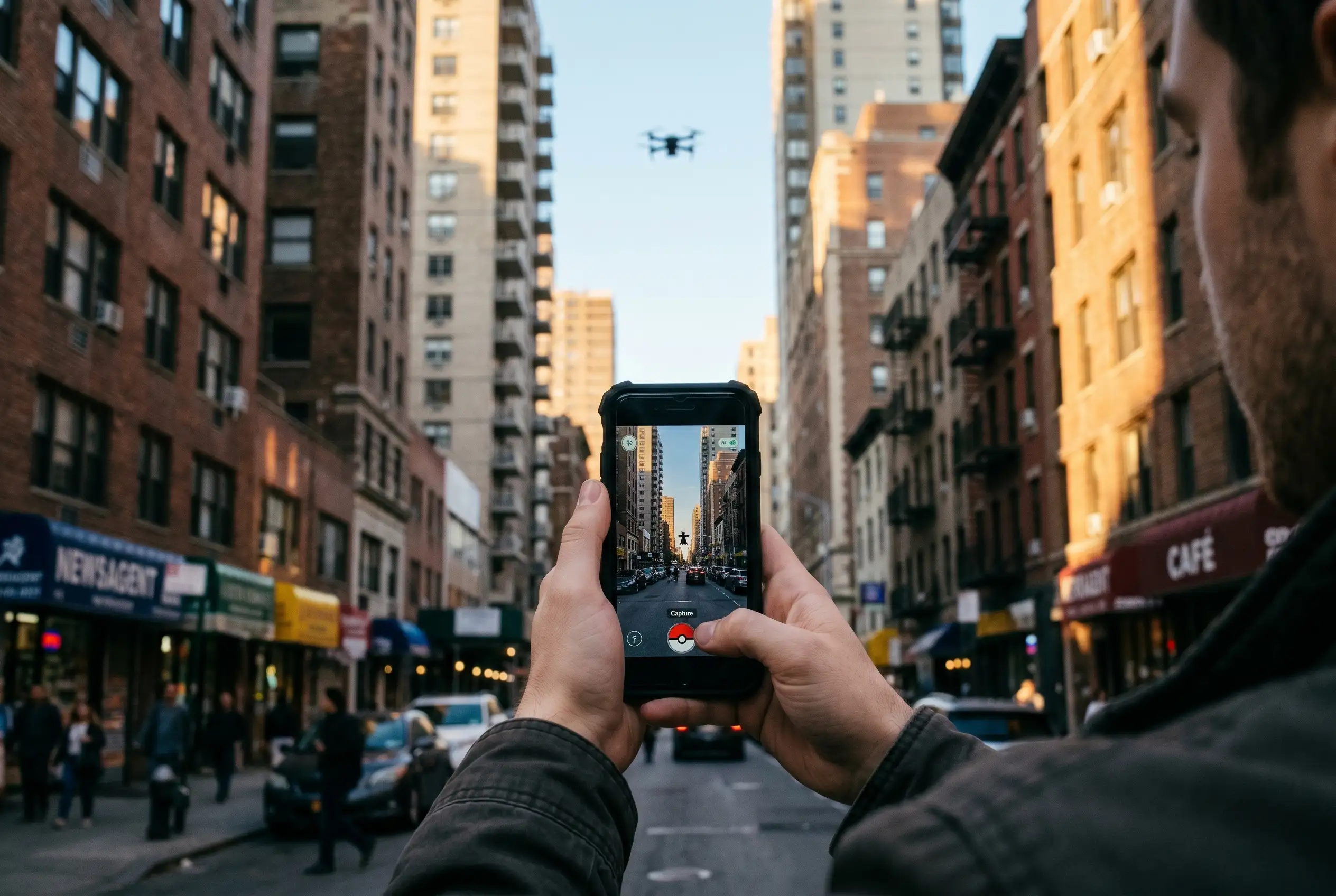
A visual positioning system, or VPS, works by matching a live camera feed against that 3D map to estimate where a device is, useful indoors, in dense city streets, and in regions where satellite signals are jammed or spoofed. The rationale for that ground-truth mapping is laid out in Niantic Spatial’s own explainer on visual positioning. The same dataset also powers Niantic Spatial’s separate work with the delivery robot company Coco Robotics, a deal announced in March 2026 and billed as the company’s first robotics customer.
- 100 million Pokémon Go players in 2024
- 1 million+ hotspots with centimeter-level localization
- 500 million installs in the game’s first 60 days
Niantic Spatial Splits From the Game It Once Was
In May 2025, Niantic sold its licensed games, including Pokémon Go, to Scopely, a mobile publisher controlled by Saudi Arabia’s Savvy Games Group, in a deal reported at $3.5 billion. The two businesses now sit in separate companies. Niantic spun out its mapping and AI technology as a separate company called Niantic Spatial the same month, with John Hanke, the former head of Niantic and a co-creator of Google Earth, as chief executive.
The split is the structural reason a defense deal is possible at all. Niantic Spatial owns the visual positioning system and the trained model, and is free to license it to commercial and government customers. Scopely’s Niantic owns the live game and the data its current players generate, a separation the two companies have pointed to when asked about the military partnership. Player scans submitted between 2019 and May 2025 were collected under a transferable, sublicensable license, which is the legal basis on which Niantic Spatial says it can keep using the data it trained on. The scans themselves are the property the spinout brought with it, not a feed from the live game that Scopely now runs. The Scopely acquisition was covered by The New York Times in March 2025.
Niantic Spatial said in a June 12, 2026 statement that “Pokémon Go data is not shared with Niantic Spatial” now that the game belongs to Scopely. The company also said that “AR Scans collected through Pokémon Go were submitted voluntarily by players who opted into the feature and were subject to the applicable Terms of Service and Privacy Policy at the time.” The statement, sent to Game Developer, added that the discontinuation of AR scanning was part of the transition planning associated with the move to Scopely. The distinction the company is drawing is between the scans it already has, which it owns, and the scans current players might submit, which it says it does not receive.
The corporate split also means that future scans from current Pokémon Go players do not flow to Niantic Spatial, and that the existing model is the result of footage submitted between 2019 and the May 2025 transition. That distinction is the one the companies have leaned on, and the one that critics, including the Dutch ethicist Jeroen van den Hoven, have called insufficient. A player community thread on the Scopely sale catalogued the public reaction at the time.
The Niantic-Vantor Partnership
Vantor announced the joint work on December 16, 2025, a public statement that names GPS “unavailability, spoofing, interference, and jamming” as the target vulnerability. The joint product pairs Niantic Spatial’s ground-based VPS with Vantor’s Raptor software and 3D terrain data, so that a drone overhead and a vehicle on the ground can share coordinates in real time without a satellite link, according to the December 2025 Niantic-Vantor partnership announcement. Field testing of the integrated system is planned for early 2026. The companies’ framing is blunt about the intended customers: autonomous drones, ground vehicles, augmented reality glasses, and other field assets in environments where GPS does not work.
Vantor is not a startup. The company was rebranded from Maxar Intelligence on October 1, 2025, and runs as a prime contractor to the National Geospatial-Intelligence Agency, including a follow-on award worth $70 million under the agency’s Global Enhanced GEOINT Delivery program, a system that serves more than 400,000 U.S. government users, with separate contracts across the U.S. military and the Department of Homeland Security. Coverage of the partnership also appeared in SpaceNews’s write-up of the GPS-free navigation deal and in the formal BusinessWire press release.
| Attribute | Niantic Spatial | Vantor |
|---|---|---|
| Origin | Spun out of Niantic in May 2025 | Rebranded from Maxar Intelligence on October 1, 2025 |
| Core technology | Ground-based Visual Positioning System (VPS) and large geospatial model | Raptor aerial VPS software and 3D terrain data |
| Data origin | Crowdsourced AR scans from Pokémon Go and Ingress players | 20+ years of satellite imagery reconstructed into 3D terrain |
| Field-test accuracy | Centimeter-level localization under the right conditions | 3-meter-accurate global reference |
| Government exposure | First major defense deal with Vantor | NGA prime contractor; $70M follow-on award; contracts with U.S. military and DHS |
A Vantor spokesperson said the company “is not using any Pokémon Go data, nor do we have access to any information from the Pokémon Go dataset.” Niantic Spatial separately said the Vantor agreement “does not include direct sharing of game data.” Niantic Spatial has also said that ground scans “were an entirely optional feature in games” and that the company “has been transparent about the fact that the scans would improve our technology platform since 2019 in our privacy policy and public announcements.” Both companies have stopped short of saying whether the underlying model, which was trained on the scans before the Vantor deal, is the system Vantor is now adapting. Defense trade press tracked the deal as it developed, including ExecutiveBiz’s piece on the visual positioning partnership and Defense Daily’s coverage of the air-and-ground navigation solution.
What the Early Field Tests Showed
Tory Smith, Niantic Spatial’s director of product management, joined Vantor’s Josh Sisskind on a panel at the Defence Geospatial Intelligence (DGI) conference in London in February 2026, per the February 2026 DGI panel on GPS-denied operations. The panel, moderated by Charlie Houseago, Niantic Spatial’s research productization lead for spatial AI, included an edited Q&A the companies later published.
Smith said that, in early testing, combining Niantic Spatial’s VPS with Vantor’s terrain data and Raptor software produced a 70% reduction in positioning error and accuracy to within 1.5 meters in many scenarios. GPS typically gives around five meters of accuracy. In a poll of the DGI audience, 59% said jamming and challenging topography caused signal loss in their operations, and 59% ranked accuracy as the top decision factor in adopting new positioning technology.
The same flexibility is the selling point for the commercial side, where robots from Coco and other companies can run the visual positioning software on the cameras they already carry, with the integration working through an SDK that manufacturers can plug into existing systems. Sisskind told the DGI audience that Raptor is designed to run on the electro-optical camera already installed on a drone or similar platform.
GPS is increasingly unreliable in modern conflict zones, with Russia and others jamming or spoofing satellite signals in active theaters. The commercial drone industry is starting to hit the same walls in dense cities, where buildings bounce satellite signals and robots can drift tens of meters off course. Smith said the goal is not to replace GPS, but to add a visual positioning layer that keeps systems aligned when GPS performance breaks down. Field testing of the integrated system is planned for early 2026, with Vantor’s Raptor designed to be the aerial half of the integration and Niantic Spatial’s VPS the ground half. A defense-industry video briefing on the partnership walked through the same integration in plain language.
Players Who Never Agreed to a Weapons Program
The Trouw report named a player. Floris De Hingh, a 34-year-old Dutch player who downloaded Pokémon Go on the first day it was available in 2016, told Trouw he had scanned the inside of his own apartment as part of the optional feature. “I was just playing a game,” he said, and added that “a game should stay a game.” He said he quit the game more than a year ago because he was tired of the updates, not because of the data terms, and called the news an enormous eye-opener.
Trouw also interviewed van den Hoven, who has spoken plainly on the question. “Without the large number of scans from all those gamers, the development of this system would never have progressed so quickly,” he told the newspaper, adding that “the players have indirectly, in a perhaps minimal but still effective way, made a contribution to military applications.” He did not condemn battlefield VPS outright, telling Trouw that if the technology helps Ukraine win a just war against an aggressor, it is a good development.
The training data came from people who thought they were catching Pikachu, under a license most never read, sold up a chain that ends at a sovereign wealth fund and a defense prime. Consent obtained for a game is not consent for a weapons program, even if the end use turns out to be defensible.
Haye Kesteloo, editor in chief and founder of the drone news site DroneXL, wrote the line in a column on the partnership. Both companies’ defenses run on the same line, with Niantic Spatial noting that scans “were an entirely optional feature in games” and that the Vantor agreement “does not include direct sharing of game data.” A Vantor spokesperson said the company “is not using any Pokémon Go data, nor do we have access to any information from the Pokémon Go dataset.” Neither company has addressed whether the underlying model, which was trained on the scans before the Vantor deal, is the system Vantor is now adapting. The public reaction is being tracked across the r/ArtificialInteligence discussion thread and a trending topic on X.
The Civilian Use Sits Alongside the Military One
The same VPS powers the delivery robot deal. Niantic Spatial announced a strategic partnership with Coco Robotics on March 10, 2026, the same week as the MIT Technology Review report on the dataset. Coco runs about 1,000 sidewalk delivery robots in Los Angeles, Chicago, Jersey City, Miami, and Helsinki, and the company’s CEO, Zach Rash, has said the fleet has made more than half a million deliveries covering a few million miles in all weather.
Rash, in MIT’s story, said the company delivers in a lot of dense areas with high-rises and underpasses and freeways, and those are the areas where GPS just never really works. McClendon added that in those urban canyons, the blue dot on a phone often drifts 50 meters, which puts you on a different block going a different direction on the wrong side of the street. Hanke, Niantic Spatial’s CEO, told the magazine that “it turns out that getting Pikachu to realistically run around and getting Coco’s robot to safely and accurately move through the world is actually the same problem.” The Coco deal runs on the same model that the Vantor partnership is testing in early 2026, as summarized in MIT Technology Review’s LinkedIn post on the deal. The same dataset is documented in a third-party analysis of the secret 3D map.
The Pattern Reaches Beyond Pokémon Go
Pokémon Go is the most public version. Niantic Spatial has signaled interest in more indoor scans, and the same visual positioning approach is being built into Meta’s smart glasses, Apple’s AR hardware, and the camera arrays on Waymo’s self-driving cars, each one feeding a model on a continuous stream of user-generated footage.
Iris Muis, a data ethics expert at Utrecht University’s Data School, told Trouw that the trap is built into the model: a user cannot picture how their data might be used later, so even careful consent at the moment of capture does not cover a future application the user would not have agreed to. British game designer Adrian Hon has gone further, advising Pokémon Go players to stop scanning and consider smaller games less likely to resell data. De Hingh, the Dutch player who told Trouw he had scanned his own apartment, has also quit the game, calling the news an enormous eye-opener. The broader cultural conversation has played out on an Instagram post summarizing the controversy, a drone community Facebook thread, and in the Matthew Ingram newsletter on the 3D map’s open question.
Niantic’s roots run back to Keyhole, a geographic data firm that took funding in 2003 from In-Q-Tel, the venture arm financed by the CIA. An In-Q-Tel release from that year stated Keyhole’s services were used to support U.S. troops during the Iraq War, and Google bought Keyhole the following year. Hanke went on to lead the team behind Google Maps, Google Earth, and Street View, before forming Niantic Labs inside Google in 2010 and spinning it out in 2015. The same company is now selling a model to a defense contractor, with footage filmed by people who thought they were playing a game inside it. The wider investor angle is captured in Yahoo Finance’s report on the Vantor partnership, the Financial Times coverage of the Scopely sale, and the Tectonic Defense breakdown of the air-to-ground system.
Frequently Asked Questions
What is Niantic Spatial?
Niantic Spatial is the AI and mapping spinout of Pokémon Go developer Niantic, incorporated in May 2025. Its main product is a visual positioning system, a software layer that estimates a device’s location by matching its camera feed against a 3D map built from roughly 30 billion crowdsourced scans. The company is led by Hanke, the former head of Niantic and a co-creator of Google Earth.
Can Pokémon Go players opt out of AR scans now?
AR scanning in Pokémon Go was a voluntary feature that Niantic said has been discontinued as part of the game’s May 2025 move to Scopely. Players who submitted scans before the cutoff granted the company a transferable, sublicensable license, and that license is what the model was trained on. Niantic Spatial says current Pokémon Go players are not sharing data with it, since the game is now owned and run by Scopely.
Did Vantor get Pokémon Go scans directly?
No. Vantor said it is “not using any Pokémon Go data, nor do we have access to any information from the Pokémon Go dataset,” and Niantic Spatial said the Vantor agreement “does not include direct sharing of game data.” Niantic Spatial has acknowledged that the scans were used to train an “early version” of its model, and has not clarified whether the model Vantor is now adapting is the same one.
Is the same technology being used for delivery robots?
Yes. Niantic Spatial announced a partnership with Coco Robotics, a sidewalk delivery robot operator, on March 10, 2026. The company runs about 1,000 robots in Los Angeles, Chicago, Jersey City, Miami, and Helsinki, and is using Niantic Spatial’s VPS to localize robots in dense city streets where GPS is unreliable. The Coco deal is positioned as the company’s first robotics customer, with the same model in the Vantor partnership.
What can current Pokémon Go players do about their data?
AR scanning is gone from the game. Current scans are not being submitted. Niantic Spatial says it has no ongoing access to data from current Pokémon Go players, because the game license has belonged to Scopely since May 2025. Players who want to know how their data may still be used can read the game’s current Terms of Service and Privacy Policy, both of which now sit with Scopely rather than Niantic Spatial.

The Former SpaceX Welder Whose $10,000 Stock Grant Became $1,046,175

Siri AI Compatible Devices: The Full List and the 12GB Catch

GameStop Pro Points End in 2026, But the $25 Fee Stays

Pokemon Go Player Scans Now Power Military Drone Navigation Tech

New Warhammer 40,000 Event Companions Lock In One Force Disposition

Xbox’s June Update Brings Five Features Beyond Its New Boot Animation

Bungie Was ‘Below the Red Line’ Before Sony’s Buyout, Ex-CM Says

One UI 9 Finally Brings the Network Speed Meter to Galaxy Phones

macOS Golden Gate Lists the Intel Apps That Will Die in macOS 28

Huawei’s HarmonyOS Can Run on 64KB of RAM, Yu Chengdong Says at HDC 2026

Subnautica 2 Studio Apologises, Holds Line on No-Kill Combat

Brent at $111 Hides the Hormuz Damage Hitting Fed and Asia

Shai Gilgeous-Alexander Wins Second Straight MVP With 83 of 100 First-Place Votes

Mitchell Matches Kobe in Game 7 Rout, Cavaliers Reach East Finals

Xperia 1 VIII Holds Price, Xiaomi 17 Max Loads Up: Week 20 Phone News

Colt Emerson Debuts, Mariners Get Swept by Padres in Vedder Cup

Rousey Finishes Carano in 17 Seconds and Hands Netflix Its MMA Opening

Samsung Strike Looms May 21 as Union Eyes SK Hynix Bonus Formula

LIRR Strike Hits Third Day as 250,000 Commuters Face a Tougher Manhattan Run

Jaylen Brown Calls Stephen A. Smith the Face of Clickbait Media
-

 TECHNOLOGY3 years ago
How to Adjust a Bulova Watch Band – An Easy Guide
-

 News3 years ago
Fred Pentland: Athletic Bilbao’s English mentor who changed the essence of Spanish football
-

 FINANCE3 years ago
Tax Planning for Every Season: Guide to Maximizing Your Tax Benefits
-

 Education3 years ago
African Ministers New Education Plan
-

 BUSINESS3 years ago
What is Entrepreneurial Operating System? A Comprehensive Guide to EOS
-

 Education3 years ago
Innovate Your Learning Journey with Technology and Enhance Education
-

 News3 years ago
Russians formally out of World Athletics Championships
-

 BUSINESS3 years ago
Top 9 Most Expensive American Cities to Rent an Apartment