
News
Quebec’s New Meteor Crater Named Uhackatik With Innu Input
Geologists confirmed Quebec’s 25-kilometer Uhackatik crater at 390 million years old, naming it with input from the Innu Council of Ekuanitshit.

A ring-shaped pit outside Magpie, Quebec, spotted for free on Google Maps by an amateur astronomer in 2024, is now a certified meteor crater. Geologists dated the impact to 390 million years ago and gave it an Innu name, Uhackatik, chosen with input from the Innu Council of Ekuanitshit.
Only about 200 confirmed impact craters exist on Earth, and this one spans roughly 25 kilometers, nearly 15 miles wide, one of the larger confirmed finds in years. An Indigenous council also had a direct say in naming it, a detail largely absent from earlier coverage of the Google Maps discovery.
The Ring at Lake Marsal
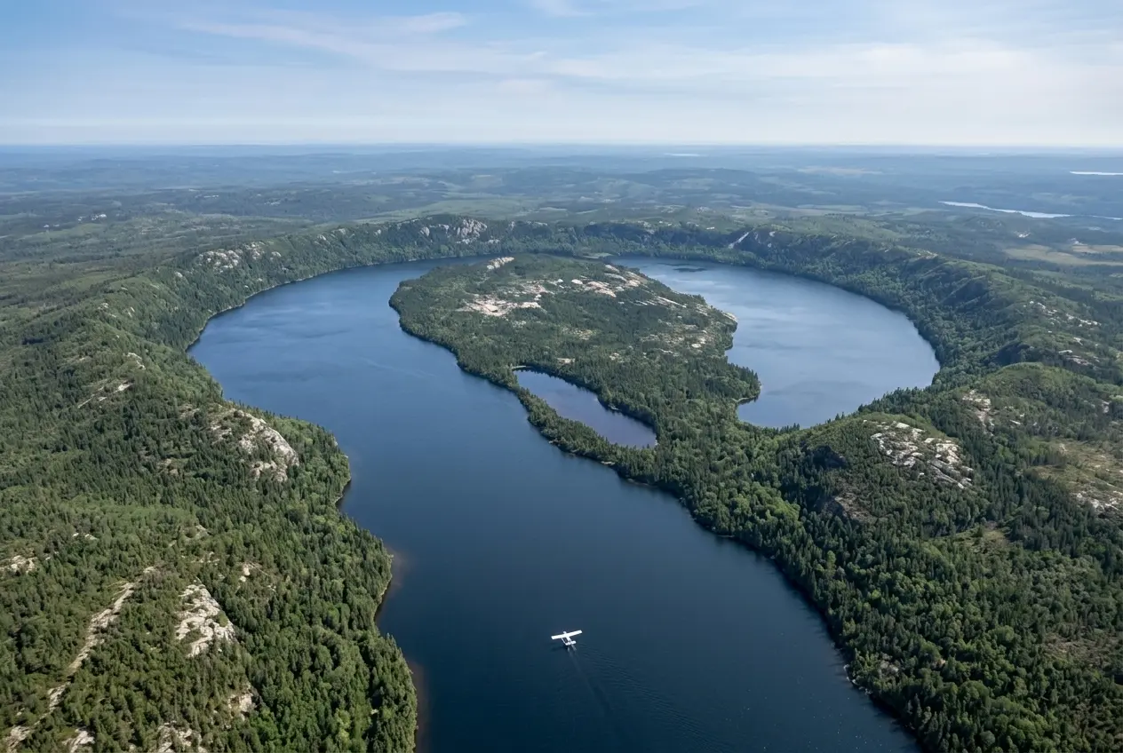
Joël Lapointe was not hunting for a crater. He is an amateur astronomer, and in 2024 he was scrolling Google Maps to plot a camping route through Quebec’s Côte-Nord region when a near-perfect ring caught his eye, centered on a remote body of water called Lake Marsal, roughly 100 kilometers north of the village of Magpie.
The shape did not read like an ordinary ditch. Lapointe noticed a ring of low, forested hills, about 8 kilometers across, wrapped tight around the lake, sitting inside a wider depression he first judged at roughly 15 kilometers wide.
He reached out to Pierre Rochette, a French geophysicist with the Centre de Recherche en Géosciences de l’Environnement in Aix-en-Provence. Rochette reviewed the imagery and told him the surrounding topography was “very suggestive” of an impact.
That early read undersold it. Once geologists actually reached the site, they pinned the confirmed structure at roughly 25 kilometers, or about 15 miles, across, well beyond the first estimate. That still leaves Uhackatik far from the largest crater on record. South Africa’s Vredefort structure tops a map of Earth’s largest confirmed impact craters at 160 kilometers across, formed over 2 billion years ago. But 25 kilometers is still large enough that finds this size are rare.
Shatter Cones and Melted Rock Seal the Case
Confirming a hunch like Lapointe’s takes more than a satellite photo. In 2025, a four-person team of geologists, Gordon Osinski, Anthony Lagain, Jérôme Gattacceca and Yoann Quesne, flew in to check.
Osinski, a professor of planetary geology at Western University, called it one of the toughest trips of his career. He has led 25 expeditions into the Arctic and worked on six continents. “It was one of the hardest field expeditions I’ve ever done,” he said.
The float plane carrying the crew could not reach shore. It set them down roughly 50 meters out, more than 150 feet, and they waded in hauling their gear through terrain Osinski described bluntly: “The terrain was incredibly rough and rugged, plus lots of bugs.”
Early rock samples held zircon, a mineral often produced in impacts, but zircon alone proves nothing. The team needed harder evidence, and it turned up fast.
- Zircon crystals showed up in the first samples, a hint but not proof by itself.
- Shatter cones, branching fracture patterns that form only under the extreme pressure of an impact or a nuclear blast, appeared on the expedition’s second day.
- Impact melt rock, stone that briefly turned to liquid, gave the team what Osinski called “spectacular examples” of the crust melting on contact.
The shatter cones settled the argument. “Those are essentially unequivocal evidence of meteorite impact,” Osinski said. Of the melted rock, he added, “You can melt literally tens of cubic kilometres of the Earth’s crust when you get a big enough asteroid hitting.” Lab work later dated the impact to 390 million years ago, inside the Devonian period. Fewer than 200 confirmed impact structures exist anywhere on Earth, tracked in the master list of confirmed impact structures kept by the University of New Brunswick, and new ones surface at a rate of roughly one or two a year.
The Innu Council of Ekuanitshit Named It Uhackatik
Once the crater’s origin was settled, it needed an official name. Osinski, Rochette and the rest of the team chose Uhackatik after discussions with the Innu Council of Ekuanitshit, the governing body of an Innu community on Quebec’s North Shore whose traditional territory includes the site.
The word Ekuanitshit itself means “where things run aground,” according to a profile of the Ekuanitshit Innu community’s territory, a fitting echo for a crater carved when a chunk of space rock ran aground in the crust nearly 400 million years ago.
Lapointe welcomed the outcome. CBC News reported that, in a message to Radio-Canada (the CBC’s French-language service), he also praised the choice of name for the site he had stumbled across two years earlier.
Egypt’s Kamil Crater Wrote This Playbook in 2008
Uhackatik is not the first crater a stranger found by scrolling satellite maps. In 2008, Italian researcher Vincenzo de Michele spotted a strange round mark on Google Earth in Egypt’s remote Uweinat Desert while actually searching for old settlement ruins.
Two years later, an Italian-Egyptian team led by meteorite curator Luigi Folco confirmed it during the 2010 expedition that confirmed Kamil crater, a site just 45 meters wide, gouged out by a 10-tonne iron meteorite less than 5,000 years ago.
| Detail | Uhackatik Crater, Quebec | Kamil Crater, Egypt |
|---|---|---|
| Spotted by | Amateur astronomer Joël Lapointe, via Google Maps | Researcher Vincenzo de Michele, via Google Earth |
| Year spotted | 2024 | 2008 |
| Confirmed by expedition | 2025 | 2010 |
| Diameter | About 25 kilometers | About 45 meters |
| Estimated age | 390 million years | Under 5,000 years |
| Key proof found | Shatter cones, impact melt rock | Meteorite fragments, rayed ejecta pattern |
The gap in scale shows how differently two impacts age. Kamil stayed pristine because it is young and sits in dry desert air. Uhackatik survived because Canada’s old, stable bedrock resists the erosion that erases most ancient craters elsewhere, which is also part of why the country holds the largest confirmed total of any nation on Earth.
Why Does Gordon Osinski Field So Many False Alarms?
Because satellite imagery makes circular landforms easy to spot and hard to verify. Osinski, who also runs a database of confirmed impact sites called Impact Earth, said the vast majority of public tips turn out to be eroded volcanoes, sinkholes or ordinary geology rather than genuine craters.
Tips have landed in his inbox for years, mostly resolving into lookalikes: collapsed magma chambers or plain old erosion. “I get lots of messages from the public thinking they have found a crater and 99/100 turn out not to be the case,” he told Live Science. “This is one of those rare examples that shows this is possible.”
- Nearly 200 confirmed impact craters exist on Earth, with only one or two new ones typically confirmed each year.
- 31 of those sit in Canada, more than any other country, and nearly a third of the Canadian total is in Quebec alone.
- An estimated 50 additional impact sites are believed to exist across the United States, though far fewer carry full confirmation.
- 25 kilometers is Uhackatik’s confirmed span, well beyond the size of most newly verified craters.
Vetting claims like Lapointe’s is effectively part of Osinski’s job. His own project, a catalogue of confirmed impact sites worldwide, exists precisely to sort real structures from the noise flooding in from armchair prospectors.
Uhackatik’s Next Stop Is a Stage in Germany
The Quebec find already has one scientific hearing behind it. Rochette presented preliminary evidence at the Meteoritical Society’s 2024 meeting in Brussels, well before the crater carried a name or a confirmed age.
Now the full case goes further. Osinski’s team will present the confirmed research next month (August 2026) at the Meteoritical Society’s annual meeting in Germany, one of the largest annual gatherings of planetary scientists in the world.
- 2024: Lapointe spots the ring on Google Maps while planning a camping trip and contacts geophysicist Pierre Rochette.
- 2024: Rochette calls the site “very suggestive” of an impact and later previews the case in Brussels.
- 2025: A four-person team led by Osinski treks into the site, finding shatter cones on the second day.
- 2026: Scientists confirm the impact, date it to 390 million years, and name it Uhackatik with the Innu Council of Ekuanitshit.
- August 2026: The full findings go before the Meteoritical Society’s annual meeting in Germany.
Osinski said the team will keep studying the rock and mineral samples they hauled out of the bush. Lapointe, for his part, has one message for anyone who spots something strange on a map. “I encourage everyone to not ignore intuition or an observation, even if it isn’t part of your field of expertise,” he said.


Walmart’s $50 Million Opioid Settlement Closes Case Without Admission

California Sues Over $120 Million Morro Bay Wind Lease Buyout

Gilead Bixlenvo FDA Nod Opens Single Pill Path for Complex HIV Cases

Meta’s $18B Kids Deal Forever Shields Data Used to Spot Under-13s

Lettuce Outbreak Drove Record Cyclospora Spike Across 20 States

Amazon Shaves $20 Off M6 Mac Mini Before It Even Ships

SpaceX Louisiana Port Tests Debt Markets on Orbital AI Scale

Microsoft High Lifts Indexes as Small Caps Crack Support

Apple Replays 2015 Saturday Midnight Preorder for iPhone 18 Pro

Updated COVID Shots Clear FDA but Access Friction Hits High-Risk Groups

Take-Two CEO Pushes Netflix Subs for GTA 6 Extended Look

Halo Campaign Evolved Skulls Meet Death Barriers That Kill the Hunt

Wildlands Free Update Hands Players the Tools They Already Invented

Destiny 2 Fans Unlock Vaulted Maps After Live Service Ends

Quake Gets 19 Free Maps From MachineGames Quake Club

Quordle Monday Delivers Gavel Crush Speed Ethos Cleanly

Stripe Bid Shows PayPal Moat Cracked After Years of Slide

Tyson’s Five-Year Utah Plant Falls to Cattle Shortage Reckoning

Silver Lake Workday Talks Signal Private Floor for Software

Kennedy Lewis Takes Majority Control of The Greenbrier in $500M Deal
-

 TECHNOLOGY3 years ago
How to Adjust a Bulova Watch Band – An Easy Guide
-

 News3 years ago
Fred Pentland: Athletic Bilbao’s English mentor who changed the essence of Spanish football
-

 FINANCE3 years ago
Tax Planning for Every Season: Guide to Maximizing Your Tax Benefits
-

 Education3 years ago
African Ministers New Education Plan
-

 BUSINESS3 years ago
What is Entrepreneurial Operating System? A Comprehensive Guide to EOS
-

 Education3 years ago
Innovate Your Learning Journey with Technology and Enhance Education
-

 News3 years ago
Russians formally out of World Athletics Championships
-

 BUSINESS3 years ago
Top 9 Most Expensive American Cities to Rent an Apartment